Rainfall, widespread flash flooding threaten 10mn people across SW US
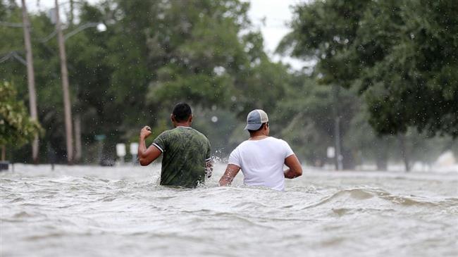
Nearly 10 million people across southwestern US states of Arizona and New Mexico as well as western Texas have been placed under severe rain and flood watches, including major cities of Phoenix, El Paso and Albuquerque.
"The stage is set for southern Arizona and New Mexico to potentially receive prolific rainfall and widespread flash flooding today," as a low-pressure system brings moist, tropical air to the Southwest in the form of heavy rain and thunderstorms to add to the already active monsoon season across the region, the official US-based Weather Prediction Center (WPC) declared on Saturday as cited in a CNN report.
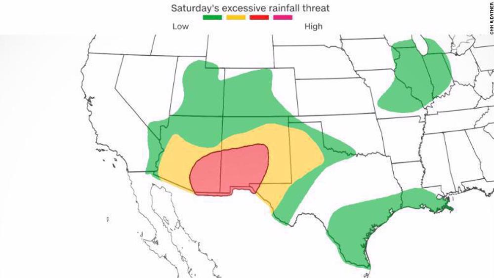
Widespread rainfall totals of two to three inches, with locally higher totals of five to seven inches, are forecast across the region -- leading the WPC to issue a level 3 out of 4 "moderate" risk for excessive rainfall ahead of the wet forecast, the report further underlined, predicting potential “widespread flash flooding across the Southwest.”
"Urban locations in addition to areas of complex terrain, slot canyons, arroyos, and burn scars are especially vulnerable for flash flooding and can quickly turn into very dangerous situations," the WPC added.
According to the government agency, the plume of moisture and heavy rainfall is expected to move into northern Texas starting Sunday into Monday -- where a level 2 out of 4 "slight risk" for excessive rainfall has been issued, with potential rainfall of nearly two to three inches per hour.
"Urban areas will be the most vulnerable to flooding for the period even with the extremely dry, drought conditions," WPC further warned.
The development comes as more than 90 percent of the state of Texas is currently experiencing drought conditions, with nearly 62 percent experiencing extreme or exceptional drought conditions -- the highest categories.
Potential Tropical Cyclone Four to bring heavy rains
Meanwhile, the National Hurricane Center (NHC) also issued a weather update on Saturday, warning of the possible formation of Tropical Cyclone Four over the western Gulf of Mexico, with sustained winds of 35 miles per hour.
A tropical storm warning is in effect for the Gulf Coast of Mexico from Boca de Catan northward to the mouth of the Rio Grande -- and across the lower Texas coast, from Port Mansfield southward to the mouth of the Rio Grande, according to the NHC, which noted that tropical storm conditions are expected across these regions in the next 12 to 24 hours as the system approaches the coast.
The system is expected to reach the coast of northeastern Mexico late Saturday afternoon, pushing inland through Sunday.
"The chances of the disturbance [Potential Tropical Cyclone Four] becoming a tropical cyclone appear to be decreasing," said an NHC advisory on Saturday, noting that the storm is located close to the coast and may not have enough time to strengthen before moving inland.
"Regardless of the system's status, the overall impacts are expected to be the same," the NHC pointed out. "Winds to tropical storm force and heavy rains are expected to spread across northeastern Mexico and southern Texas later today and continue into Sunday."
Still, heavy rain of 1 to 3 inches, with isolated totals up to 5 inches, is forecast across portions of Texas and Mexico over the next 48 hours -- which could lead to localized areas of flash flooding.

Murders by ICE ‘security agents’ spark protests

UAE official’s move to lift ban after Trump request sparks UEFA fury

FIFA and Israel given red card


Burnham becomes Labour leader in last step before taking over as UK PM
Iran says Israeli campaign to steer US into ‘unwinnable’ war will ‘soon unravel’
IRGC commander vows more ‘effective’, ‘targeted’ attacks until calm restored in Iran
Killing of environment ranger’s family in missile strike reveals true nature of US war against Iran
Iran's Mahsa Shakibaei makes history with country's first Asian cadet girls' judo title
Lawmakers warn US will face ‘dark days’ for killing innocent Iranians
Iran restores traffic on major roads within hours after terrorist US strikes
Yemeni people appreciate Iran’s efforts to break Saudi siege